Difference between revisions of "Map features.tga"
(moving top images to right on these) |
m (→Land-Bridges) |
||
| (7 intermediate revisions by the same user not shown) | |||
| Line 1: | Line 1: | ||
| + | {{DISPLAYTITLE:map_features.tga}} | ||
[[Image:Map_features.jpg|right| Enlarged section of vanilla M2TW map_features.tga]] | [[Image:Map_features.jpg|right| Enlarged section of vanilla M2TW map_features.tga]] | ||
| Line 33: | Line 34: | ||
==Land-Bridges== | ==Land-Bridges== | ||
| − | For '''M2TW only''' the ability to add long [[land-bridges]] has been added. They are shown as green lines (RGB 0,255,0) on the map_features.tga. | + | For '''M2TW only''' the ability to add long [[land-bridges]] has been added. They are shown as green lines (RGB 0,255,0) on the map_features.tga. The line of the land bridge should be only 1 pixel wide. |
| − | + | It is also still possible to use short land-bridges (as described [[land-bridges|here]] for RTW) by manipulating the coastline in map_heights.tga. | |
==Volcanoes== | ==Volcanoes== | ||
| Line 42: | Line 43: | ||
| − | + | [[Category:RTW Campaign Map Modding]] | |
| − | + | [[Category:M2TW Campaign Map Modding]] | |
| − | [[Category:Modding]] | + | [[Category:RTW Files]] |
| − | [[Category: | + | [[Category:M2TW Files]] |
| − | [[Category: | ||
| − | [[Category: | ||
Latest revision as of 08:38, 20 June 2017
The map_features.tga is the map file that controls the placing of the rivers, volcanoes and cliffs on the campaign map. In Medieval II - Total War it also controls the placing of land-bridges.
Map_features.tga will be found in the data/world/maps/base folder of a vanilla installation, it may also be placed in the data/world/maps/campaign/campaign_name folder if the other map files are copied there as well.
Contents
Size
The map_features.tga must be the same size as map_regions.tga
Rivers
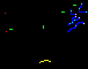
Rivers are marked with a pure blue (RGB 0,0,255) one pixel wide line.
Fords across the river are marked with a cyan pixel (RGB 0,255,255), these are the places that armies and roads can cross the river. If a river completely divides a region bounded by edge of map and or sea it may be necessary to have at least one fording position to avoid CTD on loading campaign (that appears to be linked to path finding problems).
The origin of the river must be marked with a white (RGB 255,255,255) pixel. A river must have at least one outlet, e.g. a blank end without a white origin pixel this does not have to meet the sea, but it looks rather silly if it doesn't. A river can have more than one origin with the branch joining the main river, it may also fork into different outlets. Once forks are made do not attempt to rejoin the rivers.
The river can 'step' as shown in Fig 2.
The line of the river should not be broken as in Fig 3. Diagonal corners of pixels joining is not sufficient.
A square 2 x 2 block of river pixels as shown in Fig 4. will result in a CTD without error message when attempting to generate map.rwm for new campaign.
Cliffs
Cliff positions are marked in pure yellow (RGB 255,255,0. The presence of cliffs prevents units disembarking from ships along the effected stretch of coastline.
For Rome - Total War and its' expansions a cliffs_debug.tga is generated in the root RTW folder each time a new campaign is started without a map.rwm. original author of article doesn't know what this file does! Please add info...
Land-Bridges
For M2TW only the ability to add long land-bridges has been added. They are shown as green lines (RGB 0,255,0) on the map_features.tga. The line of the land bridge should be only 1 pixel wide.
It is also still possible to use short land-bridges (as described here for RTW) by manipulating the coastline in map_heights.tga.
Volcanoes
Volcano positions are marked with one red pixel (RGB 255,0,0)


