Difference between revisions of ".worldterrain - M2TW"
| Line 4: | Line 4: | ||
See [https://www.twcenter.net/forums/showthread.php?478123-Editing-worldterrain-files-(IWTE) this tutorial] by wilddog for further information. | See [https://www.twcenter.net/forums/showthread.php?478123-Editing-worldterrain-files-(IWTE) this tutorial] by wilddog for further information. | ||
| + | |||
| + | ==Height Grid== | ||
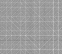
| + | The height values given in the .worldterrain file are just a series of float values with a number of rows and columns. They are applied by the game at (in milkshape equivalent terms) 8 metre spacing, using a hardcoded pattern of triangles. From experimentation this pattern is as shown in the image below; | ||
| + | [[File:Terrain-triangle-grid.jpg|200px|right]]<br> | ||
| + | You will see this pattern if you use [[IWTE]] to export a .worldterrain to ms3d or use the 'show triangles' function in the 2d editing window. The pattern can make it hard to obtain smooth gradients in certain locations and directions... | ||
| + | |||
| + | ==Merge Functions== | ||
| + | ===All Terrains=== | ||
| + | |||
| + | ===Settlement Terrains=== | ||
| + | |||
[[Category:M2TW Battle Map Modding]] | [[Category:M2TW Battle Map Modding]] | ||
Revision as of 10:24, 16 December 2019
The .worldterrain file primarily provides the height information for the battle map terrain under settlements and ambients.
The file also applies merge values which influence the rate at which the terrain under the settlement blends with the surroundings. The file also provides paths to the masks and textures applied to the area.
See this tutorial by wilddog for further information.
Height Grid
The height values given in the .worldterrain file are just a series of float values with a number of rows and columns. They are applied by the game at (in milkshape equivalent terms) 8 metre spacing, using a hardcoded pattern of triangles. From experimentation this pattern is as shown in the image below;
You will see this pattern if you use IWTE to export a .worldterrain to ms3d or use the 'show triangles' function in the 2d editing window. The pattern can make it hard to obtain smooth gradients in certain locations and directions...
