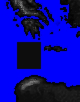
Corrected regions.tga
Corrected Regions in RTW and BI
In RTW and BI a corrected_regions.tga is created every time a new map.rwm is generated. The file can be found in the Rome - Total War folder; the same one the .exe files are in.
The above is a demonstration of how this file works. The first image is a section of the map_regions.tga this file is not altered at all. The second image is a corresponding section of the map_heights.tga with a piece of 'land' (greyscale RGB 1,1,1 or lighter)added. After addition of square island to map_heights.tga the map.rwm and map_heights.hgt are deleted and game launched, without altering any other map tga. Game loads and shows the additional square island with default ground_type. The corrected_regions.tga found in the RTW folder now shows the square island and the game has assigned the nearest regions colours to occupy the new island. When in game you will see the region boundaries as shown on the corrected_regions.tga.
What is the use of this I hear you ask....
Answer: for more complex coastlines it can be difficult to align map_regions.tga with map_heights.tga in the same manner the game does, so you can think you are adding a port in the proper position when in fact it is inland or in the middle of the sea, or you can be attempting to place a city in something the game thinks is sea. If you are experiencing such difficulties simply make a copy of the corrected_regions.tga (which shows what game thinks is the coastline) paste it into your campaign folder and re-name files so it replaces map_regions.tga, you will then have an accurate base to work on. You can then re-colour the land regions to get the region borders exactly where you want them as well.
Please note that the file 'slot' for the corrected_regions.tga is shared by all the games in your Rome - Total War folder, so do check that the last one generated is for the correct campaign before using it!
DIY corrected regions in M2TW
Unfortunately at least up to V1.1 Medieval II Total War does not produce a corrected_regions.tga, please see this post by Spur describing how to use layers in PhotoShop to give a close approximation to the same result.
The 'nearest neighbour' option in PhotoShop seems to give the closest possible result to the alignment of the coastline used by the game. Re-sizing in PaintShopPro (at least earlier versions where pixel resize is best available option) seems to give quite a large mis-match due to the somewhat different way it translates the 2x + 1pixel size difference between the two maps. (re-sizing in GIMP as yet un-tested by original author - information on that needs to be added here)


