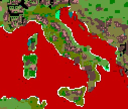
Map ground types.tga
The map_ground_types.tga is the tga that controls both the type of terrain displayed on the campaign map and on the battle map.
Map_ground_types.tga will be found in the data/world/maps/base folder of a vanilla installation, it may also be placed in the data/world/maps/campaign/campaign_name folder if the other map files are copied there as well.
Note that the map_ground_types.tga does not determine the amount or shape of sea shown on the campaign map. The coastline shown in map_heights.tga is the one that determines where land and sea are placed, if there is any discrepancy between the files a default ground type is used for the incorrectly designated areas. For instance if an island exists in map_heights.tga but is marked as sea in map_ground_types.tga it will still appear on the campaign map but with a default fertile terrain type.
Contents
Size
The map_ground_types.tga must be twice the size of map_regions.tga plus one pixel on each axis. So if map_regions.tga is 100 x 100 pixels then map_heights.tga must be 201 x 201 pixels.
Key to colours
The following key is taken from Myrddraal's tutorial Making a New Campaign Map
- Fertile Low - Grey-Blue (0, 128, 128)
- Fertile Medium - Light Green (96, 160, 64)
- Fertile High - Olive (101, 124, 0)
- Wilderness - Black (0, 0, 0)
- Mountains High - Light Brown (196, 128, 128)
- Mountains Low - Brown (98, 65, 65)
- Hills - Olive-Brown (128, 128, 64)
- Forest Dense - Dark Green (0, 64, 0)
- Forest Sparse - Green (0, 128, 0)
- Swamp - Bright Green (0, 255, 128)
- Ocean - Dark Maroon (64, 0, 0)
- Sea Deep - Dark Red (128, 0, 0)
- Sea Shallow - Red (196, 0, 0)
- Beach - White (0, 0, 0)
Impassible Land Terrain
The following types of terrain are impassible by units.
- Forest Dense - Dark Green (0, 64, 0)
- Mountains High - Light Brown (196, 128, 128)
- Mountains Low - Brown (98, 65, 65)
City and port positions in map_regions.tga should not coincide with areas of impassible terrain. Resource, watchtower and starting unit coordinates in descr_strat.txt should also not be located in areas of impassible terrain.
Use of mountain types effects the way the heights are rendered on the campaign map. Using 'mountains low' gives a smoothing effect and heights will appear lowered. Using 'mountains high' gives a peaked effect making heights appear greater, the .cas model for mountains high also places peaks randomly so they will not necessarily tie up with your highest points.
(For RTW only: Very large areas of impassible terrain can cause the same landmass crash problem as having too large a sea area.)
Other Land Ground Types
- Fertile Low - Grey-Blue (0, 128, 128)
- Fertile Medium - Light Green (96, 160, 64)
- Fertile High - Olive (101, 124, 0)
The above are fairly obviously fertile ground types, a small area of fertile ground is needed for each region. The areas of fertile terrain on the campaign map will be displayed with an overlay of a different tga when farms are built in a region, see Visual Effects on Campaign Map.
- Wilderness - Black (0, 0, 0)
- Hills - Olive-Brown (128, 128, 64)
- Forest Sparse - Green (0, 128, 0)
- Swamp - Bright Green (0, 255, 128)
- Beach - White (0, 0, 0)
Are the passable but non-fertile terrain types. They have various effects on both the campaign and battle maps. Swamp for example drastically slows down armies movement speed on the campaign map. Use of 'hills' terrain increases the apparent effect of heights on the campaign and battle map.
Sea Ground Types
The different types of sea 'ground type' affect the movement of boats.
- Ocean - Dark Maroon (64, 0, 0)
- Sea Deep - Dark Red (128, 0, 0)
- Sea Shallow - Red (196, 0, 0)
Sea shallow allows greater movement than sea deep.
In RTW the ocean ground type is impassible by ships and also therefore prevents the spawning of rebel (pirate) ships. For that reason it is best used for small lakes which don't have ports and to block of areas of the map you don't want accessible.
The area between Europe and America in M2TW is the ocean ground type - effect of ocean ground type in M2TW needs to be added here.
Visual Effects on Campaign Map
The files used as 'textures' to paint the campaign map when it is rendered are mainly contained in data/terrain/aerial_map/ground_types folder. These files are referenced from descr_aerial_map_ground_types.txt two short excerpt from that file shows how the climate as defined on map_climates.tga and the ground type combine to determine which tga is used.
climate semi_arid
{
  cultivated_low	middle_east_farm.tga
  cultivated_medium	middle_east_farm.tga
  cultivated_high	middle_east_farm.tga
  fertility_low	        fertility_5.tga
Each climate type has a separate list of all the ground types below it. Different tga's can be used for the same ground type under each of the different climates. The tga specified for cultivated_low will replace the one used for fertility_low when farms are built in a region, cultivated_medium replaces fertility_medium etc.
