Difference between revisions of "Map climates.tga"
(top, tailing and de-personalising, original version by GrnEyedDvl) |
|||
| Line 1: | Line 1: | ||
| − | + | [[Image:Map_climates.png|right|Part of M2TW map_climates.tga]] | |
| − | + | ==Overview== | |
| − | + | The map_climates.tga is the tga that controls both the type of texture used for each ground_type displayed on the campaign map and on also controls various elements of the [[battle map]]. | |
| − | + | Map_climates.tga will be found in the ''data/world/maps/base'' folder of a [[vanilla]] installation, it may also be placed in the ''data/world/maps/campaign/campaign_name'' folder if the other map files are copied there as well. | |
| − | |||
| − | 4. dense forest | + | ==Illustrations of Vanilla Campaign Map Textures== |
| − | + | The following images were supplied to illustrate the effects available by editing map_climates.tga with the [[vanilla]] texture files. | |
| − | 5. sparse forest | + | There are several images, one with each type/climate laid out side by side then a larger image of each ground_type with a strip of climate through it. |
| − | + | ||
| − | 6. hills | + | :1. low fertile |
| − | + | :2. medium fertile | |
| − | 7. impassable | + | :3. high fertile |
| − | + | :4. dense forest | |
| − | 8. mountains high | + | :5. sparse forest |
| − | + | :6. hills | |
| − | 9. mountains low | + | :7. impassable |
| − | + | :8. mountains high | |
| − | 10. wilderness | + | :9. mountains low |
| + | :10. wilderness | ||
| − | swamp and beach always look the same no matter what climate is used. | + | In the vanilla game swamp and beach always look the same no matter what climate is used. Impassable has a few different looks but not many. The pictures that follow separate the climate types so they are easier to see, and insert deciduous forest a couple of different times for a line break. |
| + | :''The pictures below were supplied by [[GrnEyedDvl]]'': | ||
http://www.twmodsquad.com/img/climates.jpg | http://www.twmodsquad.com/img/climates.jpg | ||
| Line 52: | Line 53: | ||
http://www.twmodsquad.com/img/climate10.jpg | http://www.twmodsquad.com/img/climate10.jpg | ||
| − | ' | + | ==Adding Variation to the Textures Displayed== |
| + | The textures displayed on the campaign map (see above illustrations) can be varied by changing the textures referenced in [[descr aerial map ground types.txt]]. In the vanilla game many combinations of climate and ground_type reference the same texture .tga, if additional tga's are available they can be added for selected combinations to enhance variety. | ||
| + | |||
| + | ==See Also== | ||
| + | *[[map_ground_types.tga]] | ||
| + | |||
| + | [[Category:Modding]] | ||
| + | [[Category:RTWModding]] | ||
| + | [[Category:MTW2Modding]] | ||
| + | [[Category:Map Modification]] | ||
Revision as of 13:26, 8 September 2007

Contents
Overview
The map_climates.tga is the tga that controls both the type of texture used for each ground_type displayed on the campaign map and on also controls various elements of the battle map.
Map_climates.tga will be found in the data/world/maps/base folder of a vanilla installation, it may also be placed in the data/world/maps/campaign/campaign_name folder if the other map files are copied there as well.
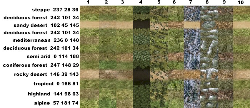
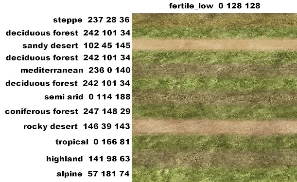
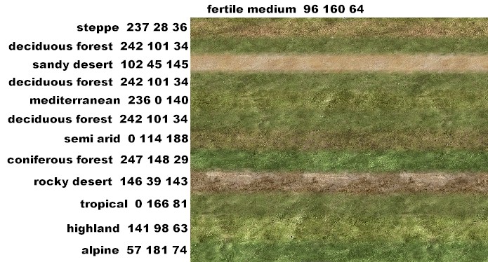
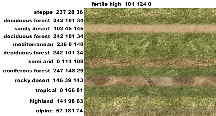
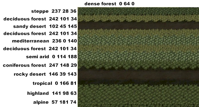
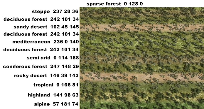
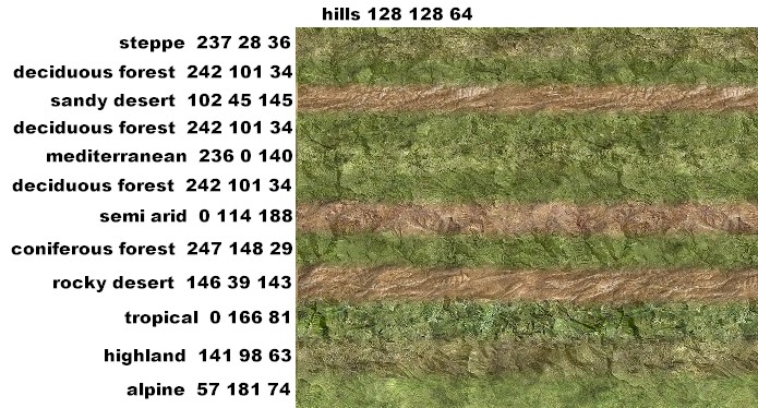
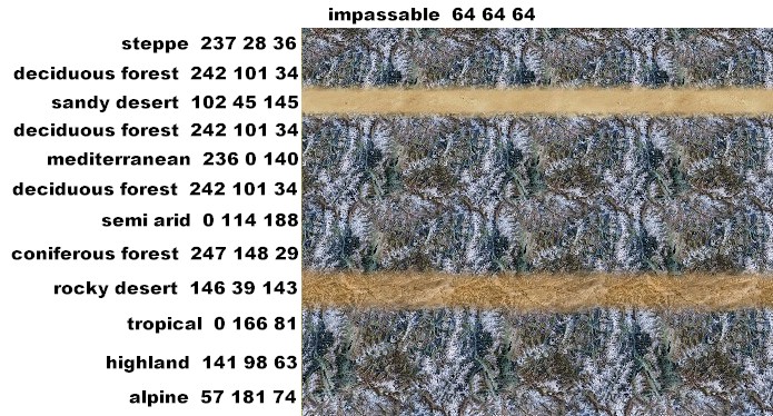
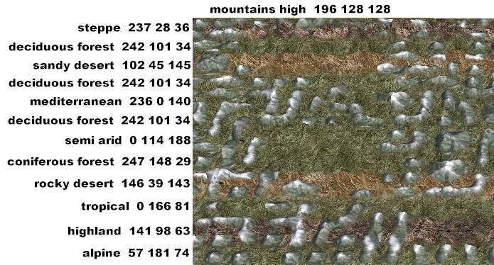
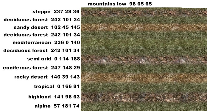
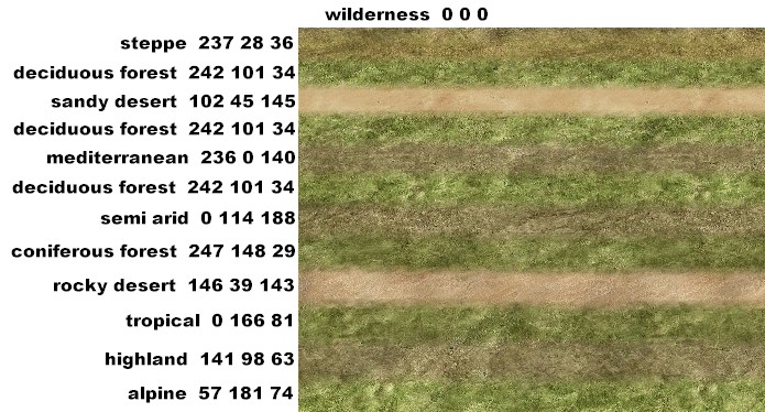
Illustrations of Vanilla Campaign Map Textures
The following images were supplied to illustrate the effects available by editing map_climates.tga with the vanilla texture files. There are several images, one with each type/climate laid out side by side then a larger image of each ground_type with a strip of climate through it.
- 1. low fertile
- 2. medium fertile
- 3. high fertile
- 4. dense forest
- 5. sparse forest
- 6. hills
- 7. impassable
- 8. mountains high
- 9. mountains low
- 10. wilderness
In the vanilla game swamp and beach always look the same no matter what climate is used. Impassable has a few different looks but not many. The pictures that follow separate the climate types so they are easier to see, and insert deciduous forest a couple of different times for a line break.
- The pictures below were supplied by GrnEyedDvl:
Adding Variation to the Textures Displayed
The textures displayed on the campaign map (see above illustrations) can be varied by changing the textures referenced in descr aerial map ground types.txt. In the vanilla game many combinations of climate and ground_type reference the same texture .tga, if additional tga's are available they can be added for selected combinations to enhance variety.