IWTE - Rome Remastered Functions
Article about IWTE functions used for Total War: Rome Remastered - Modding (for forthcoming IWTE release)
Campaign Mesh Generation
To generate a basic mesh from your base folder map_*.tga files use the "Rome Remastered" button in the top menu bar, then "Create Map Mesh", select the folder that contains your:
- map_regions.tga
- map_heights.tga
- map_ground_types.tga
- map_climates.tga
- map_features.tga
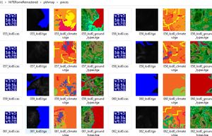
Then select any existing folder for output. Now wait a while... if all goes well you'll have a set of mesh piece .cas files to be used in game and some guide tga files showing you which sections of heights/climates/ground_types have been used:
Copy the .cas files to this folder:
- modfolder\data\terrain\campaign\pieces
Make a copy of descr_map_tiles.txt and add it to your modfolder in:
- modfolder\data\terrain\campaign
You will need entries in descr_map_tiles.txt for all the tile pieces you are going to use. Currently due to a bug that should be resolved by Feral soon... you also need to have a minimum of 104 pieces for Rome or BI maps!
Tips:
- You don't have to use exactly the same tga files that are used in game, you can adapt them if you want slightly different effects in the mesh
- IWTE expects the land parts of the heights tga to be pure greyscale, slightly off greyscale heights may not work, and/or may produce unexpected results
- Heavily 'carved' coasts made using dark blue colours to achieve sea depth to avoid visible triangles in RTW/M2TW may not work well as that actual depth will now be visible through the transparent sea surface
Task File and Options
If you make a map mesh using the button IWTE will also generate you a task file so you can refine and/or repeat the process easily. This file will be in iwte_tasks sub-folder where the IWTE.exe is located.
A minimal task file could look like:
<task_id>                                   create_map_pieces
<directory_in>                              J:/IWTERomeRemastered/pkhmap
<directory_out>                             J:/IWTERomeRemastered/pkhmap/pieces
<directory_out_increment>                   no
The optimal number of pieces a map can be split into will vary with the size and shape of the map and the amount of detail, in terms of closely spaced shore lines and mountain ranges. (trying to have large mesh pieces on a complex map is likely to exceed the number of polys that can be written to one .cas file)
The vanilla map has 104 tiles in a grid of 13x8 20m squares, we've generated a mesh for the Mundus Magnus map with similar proportions to a grid of 13x8 30m squares, as that seems to work well for a default, the default value is to use 13 squares wide... to change this default add this line to the task file:
<map_pieces_longest_dimension> 10 #with required number of tiles across the width
